Showing 1–18 of 171 results
45 UK Police Force Postcodes and Grid References
An instant download containing all UK Police Force Postcodes (circa. 1,791,294) and Postcode Grid References. The download covers all Police Forces within Northern Ireland, Scotland, Wales and England and shows the police authority within each, e.g. Thames Valley, Avon &...
Download Now
Free Postcode Area Map
This instant download provides you with a free A4 Postcode Area Map. The Postcode Area is the first one or two characters of the Postcode such as B for Birmingham or UB for Uxbridge. This Postcode Area Map of the...
Download Now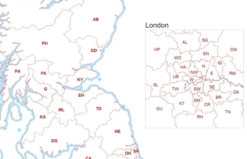
Free UK Postcodes Formatter
This instant download provides you with a free postcode formatter application (Microsoft Excel Macro). This application formats a Postcode list into a variable length e-GIF (e-Government Interoperability Framework) otherwise known as 'Print format' Postcodes, i.e. the postcode you typically see...
Download Now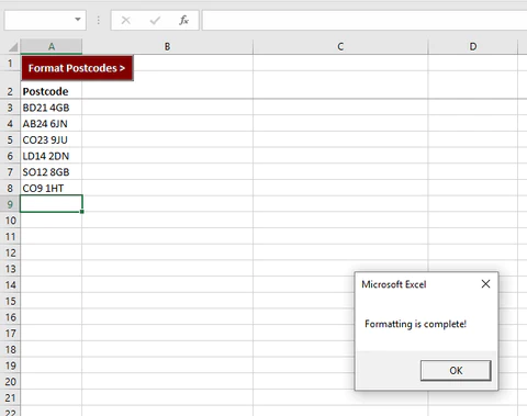
Greater London Postcodes to Administrative Wards
An instant download containing London Boroughs, Metropolitan Boroughs and Non-Metropolitan Districts divided into Wards. The City of London has its own type of Wards based on ancient and permanent sub-divisions of the City. This product is a lookup between...
Download Now
House Prices Indicator (by Postcode District)
An instant download containing over 2,200 Postcode Districts (e.g. AL1), the number of detached, semi detached, terraced and flat sales, and the average sale price for each within every PC District. This House Price file averages 9,910 households per postcode...
Download Now
House Prices Indicator (by Postcode Sector)
An instant download containing over 7,900 Postcode Sectors (e.g. AL1 7), the number of detached, semi detached, terraced and flat sales, and the average sale price for each within every PC Sector. This House Price file averages 2,990 households per postcode...
Download Now
Postcode Address File (PAF) – AB Aberdeen
This instant download contains circa. 273,804 Postcode Address File (PAF) addresses / delivery points. That’s every address, postcode and grid reference with a postcode area prefix of ‘AB’ (Aberdeen and all surrounding AB postcoded addresses). Addresses within the file are...
Download Now
Postcode Address File (PAF) – AL St Albans
This instant download contains circa. 117,864 Postcode Address File (PAF) addresses / delivery points. That’s every address, postcode and grid reference with a postcode area prefix of ‘AL’ (St Albans and all surrounding 117,864 postcode addresses). Addresses within the file are...
Download Now
Postcode Address File (PAF) – B Birmingham
This instant download contains circa. 884,492 Postcode Address File (PAF) addresses / delivery points. That’s every address, postcode and grid reference with a postcode area prefix of ‘B’ (Birmingham and all surrounding B postcoded addresses). Addresses within the file are...
Download Now
Postcode Address File (PAF) – BA Bath
This instant download contains circa. 229,630 Postcode Address File (PAF) addresses / delivery points. That’s every address, postcode and grid reference with a postcode area prefix of ‘BA’ (Bath and all surrounding BA postcoded addresses). Addresses within the file are...
Download Now
Postcode Address File (PAF) – BB Blackburn
This instant download contains circa. 240,369 Postcode Address File (PAF) addresses / delivery points. That’s every address, postcode and grid reference with a postcode area prefix of ‘BB’ (Blackburn and all surrounding BB postcoded addresses). Addresses within the file are...
Download Now
Postcode Address File (PAF) – BD Bradford
This instant download contains circa. 264,971 Postcode Address File (PAF) addresses / delivery points. That’s every address, postcode and grid reference with a postcode area prefix of ‘BD’ (Bradford and all surrounding BD postcoded addresses). Addresses within the file are...
Download Now
Postcode Address File (PAF) – BH Bournemouth
This instant download contains circa. 294,346 Postcode Address File (PAF) addresses / delivery points. That’s every address, postcode and grid reference with a postcode area prefix of ‘BH’ (Bournemouth and all surrounding BH postcoded addresses). Addresses within the file are...
Download Now
Postcode Address File (PAF) – BL Bolton
This instant download contains circa. 184,900 Postcode Address File (PAF) addresses / delivery points. That’s every address, postcode and grid reference with a postcode area prefix of ‘BL’ (Bolton and all surrounding BL postcoded addresses). Addresses within the file are...
Download Now
Postcode Address File (PAF) – BN Brighton
This instant download contains circa. 430,523 Postcode Address File (PAF) addresses / delivery points. That’s every address, postcode and grid reference with a postcode area prefix of ‘BN’ (Brighton and all surrounding BN postcoded addresses). Addresses within the file are...
Download Now
Postcode Address File (PAF) – BR Bromley
This instant download contains circa. 141,642 Postcode Address File (PAF) addresses / delivery points. That’s every address, postcode and grid reference with a postcode area prefix of ‘BR’ (Bromley and surrounding BR postcoded addresses). Addresses within the file are...
Download Now
Postcode Address File (PAF) – BS Bristol
This instant download contains circa. 490,895 Postcode Address File (PAF) addresses / delivery points. That’s every address, postcode and grid reference with a postcode area prefix of ‘BS’ (Bristol area and surrounding BS postcoded addresses). Addresses within the file...
Download Now
Postcode Address File (PAF) – BT Belfast / Northern Ireland
This instant download contains circa. 885,489 Postcode Address File (PAF) addresses / delivery points. That’s every address, postcode and grid reference with a postcode area prefix of ‘BT’ (Belfast / Northern Ireland). Addresses within the file are updated quarterly...
Download Now