Showing 1–18 of 28 results
45 UK Police Force Postcodes and Grid References
An instant download containing all UK Police Force Postcodes (circa. 1,791,294) and Postcode Grid References. The download covers all Police Forces within Northern Ireland, Scotland, Wales and England and shows the police authority within each, e.g. Thames Valley, Avon &...
Download Now
Free Postcode Area Map
This instant download provides you with a free A4 Postcode Area Map. The Postcode Area is the first one or two characters of the Postcode such as B for Birmingham or UB for Uxbridge. This Postcode Area Map of the...
Download Now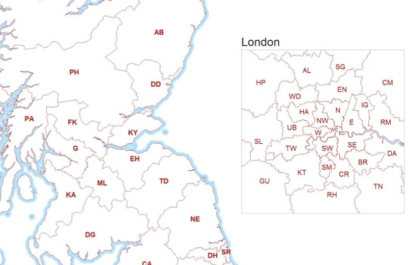
Free UK Postcodes Formatter
This instant download provides you with a free postcode formatter application (Microsoft Excel Macro). This application formats a Postcode list into a variable length e-GIF (e-Government Interoperability Framework) otherwise known as 'Print format' Postcodes, i.e. the postcode you typically see...
Download Now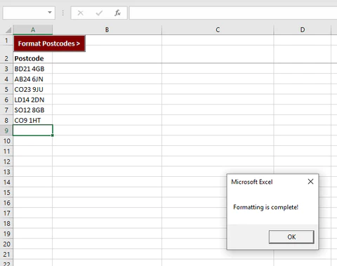
Greater London Postcodes to Administrative Wards
An instant download containing London Boroughs, Metropolitan Boroughs and Non-Metropolitan Districts divided into Wards. The City of London has its own type of Wards based on ancient and permanent sub-divisions of the City. This product is a lookup between...
Download Now
House Prices Indicator (by Postcode District)
An instant download containing over 2,200 Postcode Districts (e.g. AL1), the number of detached, semi detached, terraced and flat sales, and the average sale price for each within every PC District. This House Price file averages 9,910 households per postcode...
Download Now
House Prices Indicator (by Postcode Sector)
An instant download containing over 7,900 Postcode Sectors (e.g. AL1 7), the number of detached, semi detached, terraced and flat sales, and the average sale price for each within every PC Sector. This House Price file averages 2,990 households per postcode...
Download Now
Postcode List plus Vector Boundary files – Lower Layer Super Output Areas (LSOA)
This instant download contains 1,787,424 current live plus 888,817 retired UK Postcodes. Postcodes for England & Wales contain Middle Layer (MSOA) , Lower Layer Super Output Area (LSOA) Output Area (OA) names and codes. The vast majority of place-based data...
Download Now
Postcode Populations & Households Counts (England & Wales)
This instant download contains circa. 1,048,576 English & Welsh Postcodes, aligned to Population and Household numbers. Counts are based on addresses / delivery points featured on Royal Mail's Postcode Address File (PAF), filtered to show England & Wales postcodes....
Download Now
Postcode to UK Health Authorities (HSCB, HB/CHP, LHB, NHS)
This instant download contains every UK Postcode (circa. 1,791,296 Postcodes) and the Postcode's associated Health Authority. In addition, we include a list of circa. 892,441 'Retired' Postcodes that are no longer used by Royal Mail, showing historic HA data. The...
Download Now
Postcodes List – England
This instant download covers every known Postcode (circa. 1,489,494 ) within England. The file shows full Postcodes (e.g. YO90 1YD), Postcode Sectors (e.g. YO90 1), Postcode Districts (e.g. YO90) and Postcode Areas (e.g. YO). We have also included a 2nd...
Download Now
Postcodes List – Greater London
This instant download covers every known Postcode (circa. 180,488 ) within Greater London. The file shows full Postcodes (e.g. WD3 8UF), Postcode Sectors (e.g. WD3 8), Postcode Districts (e.g. WD3) and Postcode Areas (e.g. WD). We have also included a...
Download Now
Postcodes List – Nothern Ireland
This instant download covers every known Postcode (circa. 49,717) for Northern Ireland (NI) / BT. The file shows full Postcodes, Postcode Sectors and Postcode Districts. Included are a list of circa. 12,769 'retired' postcodes that are no longer in circulation....
Download Now
Postcodes List – Scotland
This instant download covers every known Postcode (circa. 160,133) within Scotland. The file shows full Postcodes (e.g. AB10 1AQ), Postcode Sectors (e.g. AB10 1), Postcode Districts (e.g. AB10) and Postcode Areas (e.g. AB). We have also included a 2nd list...
Download Now
Postcodes List – United Kingdom (UK)
This instant download covers every known Postcode (circa. 1.79 million) within the UK. The file shows full Postcodes (e.g. LN9 6QZ), Postcode Sectors (e.g. LN9 6), Postcode Districts (e.g. LN9) and Postcode Areas (e.g. LN). We have also included a...
Download Now
Postcodes List – Wales
This instant download covers every known Postcode (circa. 91,952 ) within Wales. The file shows full Postcodes (e.g. CF10 1AA), Postcode Sectors (e.g. CF10 1), Postcode Districts (e.g. CF10) and Postcode Areas (e.g. CF). We have also included a 2nd...
Download Now
Royal Mail’s Part Postcode Address File (Part PAF)
This instant download contains all every UK Postcode (circa. 1,791,296) and associated street/road name, locality, town name, and grid references. 'Part PAF' covers every postcode in the UK and consists of the very same fields you find in Full PAF...
Download Now
Travel to Work Areas (TTWA) Postcodes
This instant download contains circa. 1,791,296 postcodes & Travel to Work Areas/Zones (TTWA). TTWA boundaries are non-overlapping and cover the whole of the UK. TTWAs have been assigned to regions based on where the highest proportion of land area...
Download Now
UK National Park Postcodes
This instant download contains all circa. 1,791,294 Postcodes and associated National Parks (13). Postcodes within the file are updated quarterly to ensure they remain current, and our clients receive an inclusive complete refresh every three months as part of the...
Download Now